![]()
![]()
![]()
![]()
![]()
![]()
![]()
![]()
![]()
![]()
|
|
|
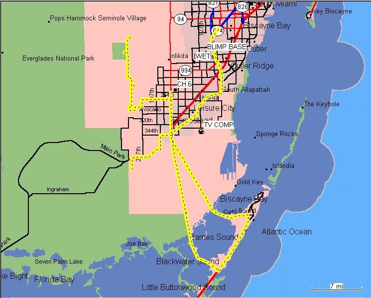
| On September 1, 2001, a group of 10 active hams toured some locations in South Dade. Part scouting trip, part hike, part educational, part history documentation. While it was a lot of fun, it also gives us information about locations around Miami-Dade where we might be called to help. I really need help explaining this stuff, so please try to describe the things we found and drop me an e-mail. I know the 'old timers' and my fellow natives know a lot of stuff about this area. Here's a map of our trip:
We started at Dade Corners, US 41 and Krome, but the track starts while we were at the first new location, Chekika Park, then 'hole in the wall' to the north, then south we found a new pumping station. While some in the group tested their vehicle's water proofing, I documented a water level telemetry station. From there, lunch at a BBQ place near Krome and SW 248 St. We tried to get to the AreoJet facility, but found a road closed. Which of course increased our curiosity even more. There's some history down there! We found an interesting phone company installation along the way. A quick stop outside an old AT&T microwave tower and over the horizon long distance facility. Another brush with history at an abandoned military radar and maybe missile base. Some pictures, but not enough to document all of it. A stop for drinks at the Circle K in Key Largo, then up the 18 mile stretch to the C111 Canal. Sally explained it's history and plans to fill it to restore the Everglades. After this, we drove north to Florida City where we split up and headed home. We were on this tour of South Dade from after the ARPSC Meeting at about noon until about 6:30 PM. Quite a day.
Places to explore in the future: Dade-Coillier Training and Transition Airport (Jetport)
http://terraserver.homeadvisor.msn.com/image.asp?S=11&T=1&X=1395&Y=7015&Z=17&W=2 http://terraserver.homeadvisor.msn.com/image.asp?S=15&T=1&X=88&Y=438&Z=17&W=2 The military place South of US 41 on Krome.
The Richmond NAS Card Sound Road bridge: http://terraserver.homeadvisor.msn.com/image.asp?S=10&T=1&X=2817&Y=13984&Z=17&W=2 Old Card Sound Road:
Beyond 405 on Card Sound:
Other locations to check into: Other sites? 08/31/2003 |
|